- Artists
Maps are constructed to represent what we know about the world, presenting information that we believe others should know. They contribute and build our view of the world while also neglecting or excluding information that we consider unimportant, irrelevant or that we just don’t want others to see.
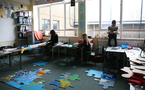
Year 10 students from City Learning Centre in Newham participated in a three-day workshop with artists Jeremy Wood and Susan Stockwell that considered how we put together a picture of the world. The first component of the workshop looked at a range of maps from the prehistoric man up to the 21st-century. Participants then worked on a world map jigsaw, each researching and representing a select area to contribute to a picture of the earth.
The second component of the workshop invited participants to ‘annotate’ the world. Using large world maps, they collaborated to draw and annotate the world with information from their own knowledge and research. This exercise informed their debate around the following questions:
What is a map?
How are maps made?
What type of information is represented in a map?
Where does the information come from?
-

- A collaborative world map produced by year 10 Newham participants © Susan Stockwell
-

- A collaborative world map by year 10 Newham participants, the map contains their annotations and information that they collected about each area © Christa Holka
-

- Participants trace an outline of a map © Susan Stockwell
-

- Participants research and add information to their world map jigsaw © Susan Stockwell
-

- A map of the world by Newham participants © Christa Holka
-

- World Map jigsaw puzzle by Year 10 participants with artists Susan Stockwell and Jeremy Wood. © Christa Holka
-

- Exhibition of Mapping the World at Rivington Place © Christa Holka
-

- Newham participants draw the world from their memory © Christa Holka
-

- Collaborative map produced by Newham participants © Christa Holka